Page Not Found
Page not found. Your pixels are in another canvas.
A list of all the posts and pages found on the site. For you robots out there is an XML version available for digesting as well.
Page not found. Your pixels are in another canvas.
This is a page not in th emain menu
Published:
This is a sample blog post. Lorem ipsum I can’t remember the rest of lorem ipsum and don’t have an internet connection right now. Testing testing testing this blog post. Blog posts are cool.
Published:
This is a sample blog post. Lorem ipsum I can’t remember the rest of lorem ipsum and don’t have an internet connection right now. Testing testing testing this blog post. Blog posts are cool.
Published:
This is a sample blog post. Lorem ipsum I can’t remember the rest of lorem ipsum and don’t have an internet connection right now. Testing testing testing this blog post. Blog posts are cool.
Published:
This is a sample blog post. Lorem ipsum I can’t remember the rest of lorem ipsum and don’t have an internet connection right now. Testing testing testing this blog post. Blog posts are cool.
Short description of portfolio item number 1
Short description of portfolio item number 2 
Published in Journal of Construction Engineering and Management, 2016
This paper is about automated project planning. It integrates workbreakdown structure and project network for earthwork projects automatically. The method aoids temporal-spatial conflicts that are typical in existing linear programming methods by a two-step approach.

Methodology overview.
Recommended citation: Duanshun Li and Ming Lu (2016). "Automated Generation of Work Breakdown Structure and Project Network Model for Earthworks Project Planning A Flow Network-Based Optimization Approach." Journal of Construction Engineering and Management. 143(1): 04016086. https://doi.org/10.1061/(ASCE)CO.1943-7862.0001214
Published in Automation in Construction, 2018
This paper is about heterogeneous information integration and visualization for site information magement. It integrates unordered images, geometric models and the 3D GIS based on Google Earth and Keyhole Markup Language.

Methodology overview.
Recommended citation: Duanshun Li and Ming Lu (2018). "Integrating geometric models, site images and GIS based on Google Earth and Keyhole Markup Language." Automation in Construction. 89(2018):317-331. https://www.sciencedirect.com/science/article/pii/S0926580517303333
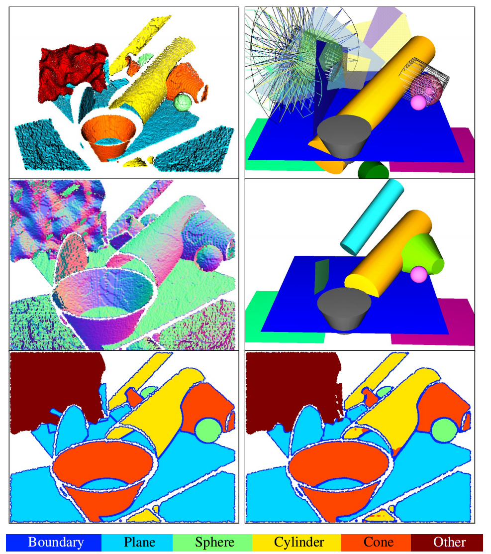
This project aims to obtain the parametric model of basic primitives from noisy point cloud.

Primitive fitting on a simulated test range image (top left) with BAGSFit (middle right) vs. RANSAC (top right). Estimated normals (middle left) and ground truth labels (bottom left) are used to train a fully convolutional segmentation network in BAGSFit. During testing, a boundaryaware and thus instance-aware segmentation (bottom right) is predicted, and sent through a geometric verification to fit final primitives (randomly colored). Comparing with BAGSFit, the RANSAC-based method produces more misses and false detections of primitives (shown as transparent or wireframe), and thus a less appealing visual result.
Undergraduate course, University of Alberta, Civil and Environemental Engineering, 2014
Graduate course, University of Alberta, Civil and Environemental Engineering, 2015
Undergraduate course, University of Alberta, Civil and Environemental Engineering, 2015